Specimen record
Determinations
Click on an OTU to show all material for that OTU
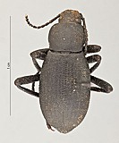
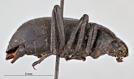
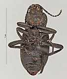
- Eleodes (Melaneleodes) humeralis LeConte, 1857 by: Rolf L. Aalbu
Identifiers
- Teneb_base 1993
Repository/location
Disposition (location etc.):
Repository:Rolf L. Aalbu
Attributes
Sex:
Stage:adult
DNA usable:false
Preparations:
Parent (e.g. part of whole specimen):
Record details
Last updator: Rebecca Dornburg
Creator: Rebecca Dornburg
Created on: about 13 years ago
Last updated: about 13 years ago
Is public?: Yes
Images
Associated collecting event
Map
Verbatim label
VII/11/1986
6.1 rd mi S Hwy90
Dodson Rd Moses Lake
Grant Co., WA
D.E. Russel
Colr.
6.1 rd mi S Hwy90
Dodson Rd Moses Lake
Grant Co., WA
D.E. Russel
Colr.
Verbatim label md5:c1a30baf461e535e485af0f56438853b
Locality
Geography:
Tied Geography:USA: Washington: Grant Co.
Locality:6.1 rd mi S Hwy 90,
Elevation: ()
Date/time
Date range:11-11..1986
Time start:
Time end:
Collection Method
Determined:
Verbatim:
Georeferencing
Verbatim latitude:344
Verbatim longitude:349
Determined lat/long:latitude: 47.013663, longitude: -119.556818
Determined uncertainty (m):3222
Lat/long undeterminable:
Locality accuracy confidence
Georeference sources:
Identifiers
Trip code:
Trip code namespace:
External/import namespace:
External/import identifer:
Habitat/hosts
Macro habitat:
Micro habitat:
Host genus:
Host species:
Notes
Used 6.1 miles S of Dodson Rd, just off Hwy 90 by Moses Lake, to find coordinates.
Validation/Errors
Error in label (not transcription):no / unchecked
Error in transcription (not entered correctly):no / unchecked
Error free (anything that appears to be error is not):no / unchecked
Geography undeterminable:no / unchecked
Record details
Last updator: Rebecca Dornburg
Creator: Rebecca Dornburg
Created on: about 13 years ago
Last updated: about 13 years ago
Is public?: Yes
