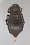
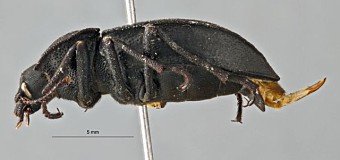
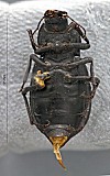
Specimen record
Determinations
Click on an OTU to show all material for that OTU
-
Stenomorpha by: stephanie delgado Animalia → Arthropoda → Insecta → Coleoptera → Polyphaga → Tenebrionidae → Pimeliinae → Asidini → Stenomorpha
Identifiers
- Teneb_base 7567
Repository/location
Disposition (location etc.):
Repository:Aaron D. Smith
Purdue University
West Lafayette, Indiana, USA
Attributes
Sex:male
Stage:adult
DNA usable:false
Preparations:
Parent (e.g. part of whole specimen):
Record details
Last updator: stephanie delgado
Creator: stephanie delgado
Created on: over 12 years ago
Last updated: over 12 years ago
Is public?: Yes
Images
Associated collecting event
Map
Verbatim label
MEXICO: Baja Cal. Sur
Sier. de la Laguna trail
el 1495m, N23°32.78’ W110°00.99’,BCS#41
28.VII.2009, ADSmith
Sier. de la Laguna trail
el 1495m, N23°32.78’ W110°00.99’,BCS#41
28.VII.2009, ADSmith
Verbatim label md5:f5eb8c36f7f85ebc0cfa842410cdea8f
Locality
Geography:
Tied Geography:Mexico: Baja California Sur
Locality:Sier. de la Laguna trail
Elevation:1495.0 meters (455.68 feet)
Date/time
Date range:28-28..2009
Time start:
Time end:
Collection Method
Determined:
Verbatim:
Georeferencing
Verbatim latitude:N23°32.78’
Verbatim longitude:W110°00.99’
Determined lat/long:latitude: 23.546333, longitude: -110.0165
Determined uncertainty (m):
Lat/long undeterminable:
Locality accuracy confidence
Georeference sources:
Identifiers
Trip code:
Trip code namespace:
External/import namespace:
External/import identifer:
Habitat/hosts
Macro habitat:
Micro habitat:
Host genus:
Host species:
Validation/Errors
Error in label (not transcription):no / unchecked
Error in transcription (not entered correctly):no / unchecked
Error free (anything that appears to be error is not):no / unchecked
Geography undeterminable:no / unchecked
Print label
MEXICO: Baja Cal. Sur
Sier. de la Laguna trail
el 1495m, N23°32.78’ W110°00.99’,BCS#41
28.VII.2009, ADSmith
Print cue:
Record details
Last updator: Rebecca Dornburg
Creator: Aaron Smith
Created on: almost 13 years ago
Last updated: almost 13 years ago
Is public?: Yes
