
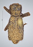
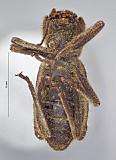
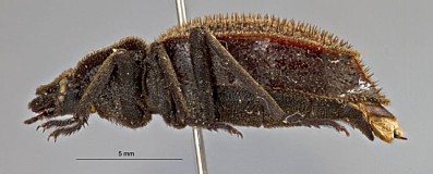
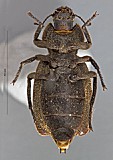
Stenomorpha (Platasida) embaphionides (Horn, 1894)
Asida (Platasida) embaphionides : Horn, 1894: 419 (original description)
Map
kml (right-click, save as)
Specimens
| identifier(s) | repository | sex | collecting event |
|---|---|---|---|
| Teneb_base 6446 | CSCA | El Prescadero 16-16..1979 M.S. Wasbauer Pitfall Trap mx id:22630 |
|
| Teneb_base 6452 | CAS | 14-14..1968 E.L. Sleeper, F.J. Moore mx id:22683 |
|
| Teneb_base 6453 | CAS | 5.5 miles South East of Valle Perdido latitude: 23.643284, longitude: -110.077669 485.0-490.0 meters 14-14..1968 E.L. Sleeper, F.J. Moore mx id:22684 |
|
| Teneb_base 6454 | CAS | 2-2..1981 mx id:22632 |
|
| Teneb_base 6455 | CAS | Boca de la Sierra 150.0 meters 7-7..1969 S.C. Williams mx id:22633 |
|
| Teneb_base 6456 | CAS | 12.4 miles East of La Pax on road to Las Cruces 4-4..1959 H.B. Leech mx id:22634 |
|
| Teneb_base 6457 | CAS | San Jose del Cabo 7-7..1988 N.D. Penny mx id:22685 |
|
| Teneb_base 6458 | CAS | San Jose del Cabo 7-7..1988 N.D. Penny mx id:22685 |
|
| Teneb_base 6459 | CAS | 26 Km North East of San Jose del Cabo 8-8..1988 D.F. Gross mx id:22686 |
|
| Teneb_base 6460 | CAS | 10 miles East of La Paz on road to Las Cruces 23-23..1958 H.B. Leech mx id:22687 |
|
| Teneb_base 6461 | USNM | Rancho La Burrera, 24 Kilometers East of Todos Santos 13-13..1981 W.E. Steiner mx id:22689 |
|
| Teneb_base 6462 | USNM | Rancho La Burrera, 24 Kilometers East of Todos Santos latitude: 23.452329, longitude: -109.994656 14-14..1981 W.E. Steiner mx id:22688 |
|
| Teneb_base 6463 | USNM | Rancho La Burrera, 24 Kilometers East of Todos Santos latitude: 23.452329, longitude: -109.994656 14-14..1981 W.E. Steiner mx id:22688 |
|
| Teneb_base 6464 | KWBC | 5.5 miles South East of Valle Perdido latitude: 23.643284, longitude: -110.077669 485.0-490.0 meters 14-14..1968 E.L. Sleeper, F.J. Moore mx id:22684 |
|
| Teneb_base 6465 | CAS | 0.7 miles North West of El Triunfo 9-9..1959 H.B. Leech mx id:22690 |
|
| Teneb_base 6466 | CAS | Punta Lobos, 1 mile South East of Tedos Santos 25-25..1958 H.B. Leech mx id:22691 |
|
| Teneb_base 6467 | CAS | Todos Santos 15-15..1938 Michelbacher, Ross mx id:22692 |
|
| Teneb_base 6468 | CAS | 7 kilometers South East of San Antonio 395.0-400.0 meters 10-10..1993 Y.F. Hsu mx id:22693 |
|
| Teneb_base 6469 | CAS | 11.1 kilometers North West of Todos Santos 19-19..1976 E.L.. Sleeper mx id:22694 |
|
| Teneb_base 6470 | CAS | 2 kilometers South of San Pedro latitude: 23.917354, longitude: -110.256799 600.0 meters 9-9..1993 Y.F. Hsu mx id:22126 |
|
| Teneb_base 6525 | KWBC | female | 5.5 miles South East of Valle Perdido latitude: 23.6592, longitude: -110.0497 485.0-490.0 meters 14-14..1968 E.L. Sleeper, F.J. Moore mx id:22193 |
| Teneb_base 6526 | EMEC | female | Ramal de San Antonio 5 miles East of Highway 1 and 7 miles South of San Antonio latitude: 23.76453, longitude: -109.998307 12-12..1983 F. Andrew, D. Faulkner mx id:22120 |
| Teneb_base 25395 | UCDC | 1 mi. S. Punta Puerto Escondido latitude: 27.855, longitude: -115.042 12.1.1984 R. Wells mx id:34307 |
|
| Teneb_base 25396 | KWBC | 0.5 mi NW El Triunfo latitude: 23.809, longitude: -110.115 5905.51 meters 1-2.11.1968 E.L.Sleeper&F.J.Moore mx id:34308 |
Images Tied to Specimens
Click image for specimen record.
Natural history notes

.
